
The depopulated village of Al-Qubayba / District of Ramla
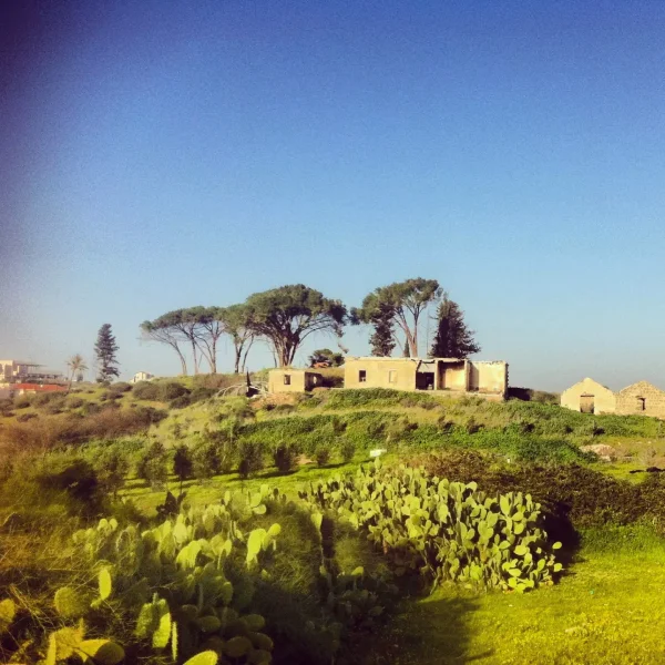
Al-Qubayba
About the depopulated village of Al-Qubayba
- District
- Ramla
- Date Al-Qubayba was occupied
- 27 May 1948
- Population in 1948
- 2,000
- Military operation
- Operation Barak
- Brigade that carried it out
- Givati Brigade
- Elevation above sea level
- 25 m
- Cause of displacement
- Expulsion by Zionist troops
- Extent of destruction
- During the 1st half of June 1948, al-Qubayba was mostly destroyed with the exception of few houses. Currently, those houses are occupied by Israeli Jewish settlers.
- Ethnic cleansing
- On the 29th of August 1948, al-Qubayba was completely ethnically cleansed.
Hover a dot to read the village name, or click to open its card.
Borders of the depopulated village of Al-Qubayba
Al-Qubayba – Depopulated Palestinian Village in Ramla Subdistrict
Al-Qubayba was a Palestinian village in the Ramla subdistrict of the Lydda district. It stood on an alluvial rise in the central coastal plain, approximately 10.5 kilometers southeast of Ramla, at an average elevation of about 25 meters above sea level.
A secondary road connected the village with the coastal highway to the west, linking it with Gaza, Ramla, and other urban centers. Agriculture—particularly citrus, vegetables, and cereals—formed the basis of the village economy and was supported by artesian wells and water from the Rubin River.
Al-Qubayba had 1,720 inhabitants in the official 1944/45 statistics and a registered land area of 10,737 dunums. Sources disagree on the precise date of its occupation in 1948: an Associated Press report citing an Israeli military communiqué gave 19 May, while another account cited by Walid Khalidi places the occupation on 27 May during the second stage of Operation Barak carried out by the Giv'ati Brigade.
Key Facts about Al-Qubayba
| Field | Information |
|---|---|
| Name | Al-Qubayba |
| Subdistrict | Ramla |
| Status | Depopulated Palestinian village |
| Distance from Ramla | Approximately 10.5 km southeast |
| Average elevation | Approximately 25 m above sea level |
| Population, 1931 | 799 in 160 houses – official census |
| Population, 1944/45 | 1,720 – official statistics |
| Registered land area | 10,737 dunums |
| Occupation date | Disputed: 19 May or 27 May 1948 |
| Military operation | Second stage of Operation Barak in the account dating the occupation to 27 May |
| Military unit | Giv'ati Brigade |
| Cause of depopulation | Palestine Remembered classifies it as expulsion; the event also falls within Giv'ati's broader village-clearing campaign during Operation Barak |
| Extent of destruction | Most of the village was destroyed, although several houses and part of the school survived |
| Settlements established at the site | Ge'alya and Kfar Gevirol |
Location of Al-Qubayba
Al-Qubayba stood on an alluvial rise in the central coastal plain, approximately 10.5 kilometers southeast of Ramla. A secondary road connected the village to the coastal highway west of the site, which led to Gaza, Ramla, and other towns.
Its lands bordered or lay near those of Zarnuqa and Yibna, while Wadi Hunayn, Bir Salim, and al-Nabi Rubin were among the nearby localities. The Rubin River, also associated with Wadi al-Sarar along its course, contributed to the area's water supply and irrigation.
The Name Al-Qubayba
The Arabic name Al-Qubayba is a diminutive form of qubba, meaning a dome. The principal sources used here do not identify a specific historical dome as the conclusively documented origin of the village name, so no more precise explanation is presented as established fact.
Al-Qubayba before the Nakba
In the late nineteenth century, the Survey of Western Palestine described Al-Qubayba as an adobe-built village on elevated ground surrounded by cultivated gardens enclosed by cactus hedges.
During the British Mandate, houses were built of adobe brick or stone. Older houses were closely clustered, while newer buildings constructed shortly before the Nakba were more widely spaced beyond the older village nucleus.
The village contained a small marketplace, a mosque, and an elementary school, while agriculture formed the main source of livelihood.
Population of Al-Qubayba
- 1931799Official census: 796 Muslims and 3 Christians
- 1944/451,720Official statistics; Khalidi describes the village population in this period as Muslim
- 19481,995Later estimate reported by Palestine Remembered, not an official census
- 199812,253 refugeesLater estimate of refugees and descendants reported by Palestine Remembered
Khalidi also records that approximately 900 Bedouins had settled near the village by 1945. This figure should not automatically be added to Al-Qubayba's official population of 1,720, since it is described as a neighboring Bedouin population rather than part of the village's official count.
The 1948 and 1998 figures are later estimates and cannot be attributed to the British Mandate's 1945 Village Statistics despite the general source label displayed below Palestine Remembered's table.
Number of Houses
- 1931160Official census figure
- 1948399Later estimate reported by Palestine Remembered, not an official census count
Land Ownership in Al-Qubayba
The registered land area of Al-Qubayba in 1944/45 was 10,737 dunums.
- Palestinian8,889 dunums83%
- Transferred to Zionists1,397 dunums13%
- Communal/Public451 dunums4%
The figures balance correctly: 8,889 + 1,397 + 451 = 10,737 dunums.
The original official categories were 8,889 Arab dunums, 1,397 Jewish dunums, and 451 Public dunums.
Land Use in 1944/45
- Arab
- Jewish
- Public
- Citrus and bananas5,831 dunums
- Plantations and irrigable land1,158 dunums
- Cereals3,139 dunums
- Built-up land43 dunums
- Non-cultivable land566 dunums
The table balances correctly: 5,831 + 1,158 + 3,139 + 43 + 566 = 10,737 dunums.
Palestine Remembered's simplified table displays 543 dunums of “non-arable” land under the Palestinian column. This appears to combine the official 92 Arab dunums with 451 Public dunums. The Public category has therefore been kept separate here rather than being treated as private Palestinian ownership.
Economic Life in Al-Qubayba
Agriculture was the village's principal economic activity, with citrus forming a particularly important component. In 1944/45, 5,831 dunums within the village's statistical boundaries were devoted to citrus and bananas, including 4,639 Arab dunums and 1,192 Jewish dunums.
Cereals covered 3,139 dunums, while plantations and irrigable land totaled 1,158 dunums. Villagers also cultivated vegetables and other fruit crops.
The village's modest marketplace served local residents, while its road connections provided access to Ramla and coastal urban markets.
Water and Irrigation
Al-Qubayba drew water from artesian wells, while Rubin River water was used for irrigation.
These resources were especially important for the village's citrus groves, orchards, and vegetable cultivation, all of which depended on regular irrigation.
Education in Al-Qubayba
An elementary school was established in Al-Qubayba in 1929. It had a twelve-dunum agricultural annex in which pupils were taught principles of scientific agriculture, reflecting the close relationship between education and the village economy.
Approximately 344 pupils were enrolled during the 1945/46 school year.
Part of the school building remained standing in the later field documentation used by Walid Khalidi.
Mosque and Religious Institutions
Khalidi documents a mosque in Al-Qubayba before the Nakba.
Palestine Remembered's automated statistics page also displays a church entry, but Khalidi's detailed account does not document a church and describes the village population in the late Mandate period as Muslim. The church entry has therefore not been treated as a verified village institution.
Operation Barak
The Haganah launched Operation Barak in May 1948. The Giv'ati Brigade was its principal force, while the Palmach's Negev Brigade participated on another axis.
PalQuest's summary fields date Operation Barak to 9–13 May, but the detailed narrative states that a second stage began after the British withdrawal on 15 May and continued through the end of the month.
The campaign targeted villages south and west of Ramla. PalQuest, citing military orders discussed by Israeli historian Benny Morris, records that one of the operation's aims was to remove a large number of Palestinians from villages in the occupied area.
Thus, whether Al-Qubayba was occupied on 19 or 27 May, its capture falls within the chronology of Operation Barak's second stage rather than being confined to the summary 9–13 May dates.
Occupation and Depopulation of Al-Qubayba
The sources disagree over the exact date of Al-Qubayba's occupation.
An Associated Press report citing an Israeli military communiqué stated that the village was occupied on 19 May 1948.
Walid Khalidi, however, cites Benny Morris as placing the occupation on 27 May during the second stage of Operation Barak, carried out by the Giv'ati Brigade under Shim'on Avidan.
The New York Times was also cited as reporting that Al-Qubayba and neighboring Zarnuqa were taken after a battle lasting approximately four hours.
Because these reports differ, 27 May should not be presented as a universally agreed date, even though Palestine Remembered adopts it in its summary table. The more accurate treatment is to record both 19 and 27 May and note that all accounts place the village's occupation in the second half of May during the Giv'ati advance in the Ramla area.
Palestine Remembered classifies the cause of depopulation as expulsion by Zionist forces. PalQuest's account of Operation Barak also states that villagers remaining after occupation were subject to expulsion as part of Giv'ati's practices during the campaign.
Khalidi's village-specific entry does not, however, provide a separate detailed account of a written expulsion order or the precise route by which Al-Qubayba's inhabitants left. Expulsion is therefore retained as the classification given by Palestine Remembered and as consistent with the operation's documented policy, without inventing village-specific details that are not independently recorded.
Destruction of Al-Qubayba
Al-Qubayba was subjected to extensive demolition after its occupation. By 20 June 1948, the scale of destruction had become an issue discussed in an Israeli government meeting, according to the account reproduced by Khalidi.
The discussion reportedly included financial concerns over the destruction of doors, window frames, tiles, and other reusable building materials.
The village was not completely erased: several Palestinian houses and part of the school survived into later field documentation.
Occupation Chronology
- 9–13 May 1948 according to PalQuest's summary fields
First stage of Operation Barak
The Giv'ati Brigade began its campaign against villages south and west of Ramla.
- After 15 May 1948
Second stage begins
PalQuest's detailed narrative states that the second stage began after the British withdrawal and continued through the end of May.
- 19 May 1948
First reported occupation date
An Israeli military communiqué reported by Associated Press gave this date.
- 27 May 1948
Second reported occupation date
Date cited by Khalidi from Benny Morris and associated with the second stage of Operation Barak and the Giv'ati Brigade.
- May 1948
Battle for Al-Qubayba and Zarnuqa
The New York Times was cited as reporting a battle lasting approximately four hours before the two villages were taken.
- During the occupation in the second half of May
Depopulation
Palestine Remembered classifies the cause as expulsion; Khalidi does not provide a separate detailed village-level account of the departure.
- By 20 June 1948
Extensive destruction documented
The scale of demolition was discussed in an Israeli government meeting on that date.
The English Palestine Remembered page separately states that “ethnic cleansing” was completed on 29 August 1948. The same page, however, places occupation and expulsion in May and gives no explanation of a separate August event. Because Khalidi's detailed account does not substantiate that date, it has not been adopted here as a separate stage in the village's depopulation chronology.
Israeli Settlements on Al-Qubayba's Lands
| Settlement / Locality | Established | Relationship to Al-Qubayba |
|---|---|---|
| Ge'alya | 1948 | Established at the village site |
| Kfar Gevirol | Approximately 1948 | Also established at the village site as a rural residential locality, according to Khalidi |
| Kfar HaNagid | 1949 | Located nearby but established on land belonging to neighboring Yibna, not on Al-Qubayba's land |
Al-Qubayba Today
In Walid Khalidi's field description, the rubble and collapsing walls of Palestinian houses were intermingled with buildings constructed by the two Israeli localities established at the site.
Several village houses remained standing. One was a medium-sized stone house used as a residence, while another had been converted into a restaurant. Part of the school building also remained.
Cactus hedges, sycamore trees, and several palm trees survived at the southern end of the site, while a former water basin had been used as a garbage dump.
PalQuest dates one field photograph of Al-Qubayba to June 1987. Khalidi's description therefore reflects the condition of the site during fieldwork undertaken before the publication of All That Remains in 1992 and should not be treated as a comprehensive direct field verification of conditions in 2026.
Palestine Remembered also contains later community documentation, including images labeled 1982 and 2010 as well as more recent contributions. These materials are useful for tracing the survival of houses and other remains but do not constitute a comprehensive independent survey of all village lands.
Sources
- PalQuest – Interactive Encyclopedia of the Palestine Question: Al-Qubayba, Ramla
- PalQuest – Operation Barak
- Palestine Remembered – Al-Qubayba, Ramla District
- Walid Khalidi – All That Remains: Al-Qubayba
- Government of Palestine – Census of Palestine 1931: Ramle Sub-District
- Institute for Palestine Studies – All That Remains, Walid Khalidi
Photo gallery


Photos from the village's people
Photos sent in by visitors and published after review.
Add a photo of this village
Log in to add photos of this village.
Other villages from Ramla
More from the archive


 Download Our Palestine App
The whole archive in the palm of your hand: depopulated villages, the Nakba, the massacres and Al-Aqsa — free, with no ads to erase the story.
Download Our Palestine App
The whole archive in the palm of your hand: depopulated villages, the Nakba, the massacres and Al-Aqsa — free, with no ads to erase the story.



Comments
No comments yet — be the first to write one.
Add your comment
Name and email are optional. Comments appear after review.