
The depopulated village of Al-Muzayri'a / District of Ramla
Al-Muzayri'a
About the depopulated village of Al-Muzayri'a
- District
- Ramla
- Date Al-Muzayri'a was occupied
- 12 July 1948
- Population in 1948
- 1,350
- Military operation
- Operation Dani
- Distance from the governorate centre
- 15 (km) Northeast of al-Ramla
- Elevation above sea level
- 110 m
- Cause of displacement
- Military assault by Zionist troops
- Extent of destruction
- al-Muzayri'a was completely defaced, and only house rubble left behind.
- Ethnic cleansing
- al-Muzayri'a inhabitants were completely ethnically cleansed.
Hover a dot to read the village name, or click to open its card.
Borders of the depopulated village of Al-Muzayri'a
Al-Muzayri'a – Depopulated Palestinian Village in Ramla Subdistrict
Al-Muzayri'a was a Palestinian village in the Ramla subdistrict of the Lydda district. It stood on a limestone hill at the western end of the Ramallah highlands overlooking the coastal plain, approximately 15 kilometers northeast of Ramla, at an average elevation of about 110 meters above sea level.
The village had 1,160 inhabitants in the official 1944/45 statistics and a registered land area of 10,822 dunums. Agriculture remained the main economic activity, especially cereals, citrus, and irrigated orchards, alongside several crafts practiced by some villagers in earlier decades.
Walid Khalidi's account places the occupation of Al-Muzayri'a on 12 July 1948 during the first stage of Operation Dani and the assault on Ramla. The force that occupied the village was described as the formation advancing on Ramla from the north, but the village-specific source does not independently identify the brigade or battalion that entered Al-Muzayri'a.
Key Facts about Al-Muzayri'a
| Field | Information |
|---|---|
| Name | Al-Muzayri'a |
| Subdistrict | Ramla |
| Status | Depopulated Palestinian village |
| Distance from Ramla | Approximately 15 km northeast |
| Average elevation | Approximately 110 m above sea level |
| Population, 1931 | 780 in 186 houses |
| Population, 1944/45 | 1,160 |
| Registered land area | 10,822 dunums |
| Occupation date | 12 July 1948 |
| Military operation | Operation Dani |
| Village-specific attacking unit | A force advancing on Ramla from the north; the village entry does not independently identify the brigade or battalion |
| Cause of depopulation | Palestine Remembered classifies it as direct military assault |
| Extent of destruction | Most village buildings were destroyed, while a small number of houses and other remains survived |
| Settlements on village land | Nehalim and Mazor, both established in 1949 |
Location of Al-Muzayri'a
Al-Muzayri'a stood on a limestone hill at the western edge of the Ramallah highlands overlooking the coastal plain.
A wadi ran along the village's southern boundary, separating it from Qula. Al-Muzayri'a stood east of the main road running from Ramla toward Jaffa and Tel Aviv through Majdal Yaba and approximately one kilometer east of the Ramla–Haifa railway.
Its lands adjoined those of Qula, Rantiya, Majdal Yaba, Dayr Ballut, and other communities at the transition between the coastal plain and the inland hills.
Al-Muzayri'a in the Ottoman Period
In 1596, Al-Muzayri'a was a village in the nahiya of Jabal Qubal in the liwa' of Nablus, with a recorded population of approximately 39.
Villagers paid taxes on wheat, barley, olives, goats, beehives, and other forms of production.
Khalidi records that the village appears to have been abandoned during the seventeenth century and reoccupied during the eighteenth century by the al-Rumayh family, originally from Dayr Ghassana.
Al-Muzayri'a in the Nineteenth Century
The journalist and traveler A. Mansell recorded passing Al-Muzayri'a during the 1860s.
By the late nineteenth century, the Survey of Western Palestine described it as an adobe village on the edge of the hills near Qula.
Village Layout and Buildings
Al-Muzayri'a developed a star-like layout as houses extended along the network of roads connecting the village to surrounding rural communities.
Most houses were constructed of adobe. The village center contained its mosque, school, and local services.
The official 1944/45 statistics classified approximately 25 dunums as built-up land.
Population of Al-Muzayri'a
- 159639Historical Ottoman-era figure
- 1922578Official British Mandate census; all Muslims
- 1931780Official census; all Muslims
- 1944/451,160Official Village Statistics; all Arabs
- 19481,346Later estimate reported by Palestine Remembered, not an official census
- 19988,263 refugeesLater estimate of refugees and descendants reported by Palestine Remembered
The population was predominantly Muslim. The 1948 and 1998 figures are later estimates and should not be attributed to British Mandatory Village Statistics.
Number of Houses
- 1931186Official census figure
- 1948320Later Palestine Remembered estimate, not an official census count
Land Ownership in Al-Muzayri'a
The registered land area of Al-Muzayri'a in 1944/45 totaled 10,822 dunums.
- Palestinian9,042 dunums84%
- Transferred to Zionists1,450 dunums13%
- Communal/Public330 dunums3%
The figures balance correctly: 9,042 + 1,450 + 330 = 10,822 dunums.
The original official categories were 9,042 Arab dunums, 1,450 Jewish dunums, and 330 Public dunums.
Land Use in 1944/45
- Arab
- Jewish
- Public
- Cereals6,952 dunums
- Plantations and irrigable land45 dunums
- Citrus and bananas1,336 dunums
- Built-up land25 dunums
- Non-cultivable land2,464 dunums
The figures balance exactly: 6,952 + 45 + 1,336 + 25 + 2,464 = 10,822 dunums.
Some simplified Palestine Remembered displays treat all 2,464 dunums of non-cultivable land as Arab/Palestinian. The official breakdown shows that 2,134 dunums were Arab and 330 Public, and the Public category is therefore kept separate here.
Economic Life
Agriculture remained the principal economic activity until the Nakba.
Rain-fed cereals were particularly important. In 1944/45, cereals occupied 6,952 dunums within the village's statistical boundaries, including 5,895 Arab dunums and 1,057 Jewish dunums.
Citrus and bananas occupied 1,336 dunums, of which 953 were Arab and 383 Jewish. Another 45 dunums were irrigated or used for plantations.
Earlier in the twentieth century, some villagers made cloaks and horse saddles, although these crafts gradually declined and disappeared.
Education in Al-Muzayri'a
A boys' school was founded in 1919 and became a full elementary school in 1945.
The school served children from Al-Muzayri'a and nearby villages and had approximately 207 pupils in the mid-1940s.
A plot of 35 dunums was attached to the school.
A girls' school opened in 1945 with an initial enrollment of 78 pupils.
Mosques and the Shrine of al-Nabi Yahya
Al-Muzayri'a had a mosque in the center of the village.
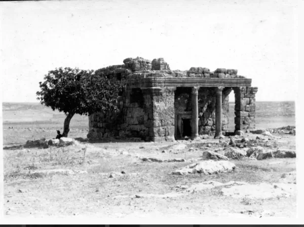
A nearby Roman mausoleum had long before been converted into a mosque dedicated to al-Nabi Yahya, or John the Baptist, and became one of the area's principal religious and archaeological landmarks.
Palestine Remembered's automated page displays a church entry, but Khalidi's detailed account does not document a church. It describes the villagers as predominantly Muslim and specifically records the central mosque and the al-Nabi Yahya mosque. The church entry has therefore not been treated as independently verified.
Archaeological Sites
Several archaeological ruins lay in the vicinity in addition to the Roman mausoleum converted into a mosque.
Khirbat Zikhrin, approximately one kilometer northeast of the village, was a Roman-Byzantine site that was also inhabited during the Mamluk and Ottoman periods.
Khalidi records that archaeological excavation there had been continuing since 1982 at the time of his documentation.
Operation Dani
Operation Dani began on 9 July 1948 and continued until 18 July. It was the largest Israeli offensive launched during the “Ten Days” between the two truces.
The operation had two stages. The first, from 9 to 12 July, targeted Lydda, Ramla, and surrounding villages. The second, from 13 to 18 July, extended eastward toward the Jerusalem corridor and the Ramallah–Latrun road.
The first stage involved the Har'el, Yiftach, and Eighth Armored brigades, together with infantry formations from Kiryati and Alexandroni. Other formations participated during the broader operation.
Yiftach approached Lydda and Ramla from the south, while other forces advanced from the north, occupying villages along their axes.
Occupation and Depopulation of Al-Muzayri'a
Walid Khalidi states that Al-Muzayri'a was almost certainly occupied during Operation Dani.
He cites Egyptian writer Muhammad 'Abd al-Mun'im as dating the occupation to 12 July 1948, when Israeli forces launched a three-pronged attack on Ramla.
According to this account, the formation attacking Ramla from the north swept through Al-Muzayri'a and neighboring Qula before reaching the city.
The Al-Muzayri'a village entry does not independently identify the brigade or battalion making up this formation. Since several brigades participated in Operation Dani, participation at the operational level should not automatically be converted into a village-specific attribution.
Palestine Remembered classifies the cause of depopulation as direct military assault and describes the village's Palestinian community as completely removed.
Khalidi does not provide a separate detailed account of a village-specific expulsion order or the precise route taken by the inhabitants. The occupation and depopulation are therefore firmly placed within the military assault, while a specific direct-expulsion mechanism remains attributed to the source that uses that classification.
Occupation Chronology
- 9 July 1948
Beginning of Operation Dani
The large offensive began against the Lydda-Ramla area and the Jerusalem corridor.
- 10 July 1948
Capture of villages south of Al-Muzayri'a
The History of the War of Independence places the occupation of Qula, Rantiya, and Wilhelma two days before Al-Muzayri'a.
- 12 July 1948
Occupation of Al-Muzayri'a
According to Muhammad 'Abd al-Mun'im as cited by Khalidi, the force advancing on Ramla from the north swept through Al-Muzayri'a and Qula.
- 12 July 1948
Occupation of Ramla
Ramla fell during the same first stage of Operation Dani.
- In the course of military attack and occupation
Depopulation
Palestine Remembered classifies the cause as direct military assault; Khalidi does not provide a separate village-specific expulsion order.
- 18 July 1948
End of Operation Dani
The operation ended after extending eastward into the Jerusalem corridor.
- Precise date not documented
Destruction
Most village houses were reduced to rubble, while a limited number of structures survived.
Israeli Settlements on Al-Muzayri'a's Lands
| Settlement | Established | Relationship to Al-Muzayri'a |
|---|---|---|
| Nehalim | 1949 | Established on the northwestern part of the village lands |
| Mazor | 1949 | Established on the western side of the village lands |
More recent community material has claimed that parts of the later built-up area of El'ad extend onto former Al-Muzayri'a lands. Khalidi and PalQuest do not list El'ad among the original settlements established on the village lands, so it has not been added to the table without independent cadastral verification.
Al-Muzayri'a Today
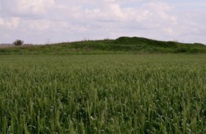
In Walid Khalidi's field description, most of the site had been planted with forest trees. Most village houses had been reduced to rubble, although a small number remained standing.
Stone terraces and cactus clusters were also still visible.
This description derives from fieldwork undertaken before the publication of All That Remains in 1992 and is therefore not a comprehensive direct verification of conditions in 2026.
Palestine Remembered contains later community documentation, including 2002 photographs of the destroyed village and the al-Nabi Yahya structure as well as later contributions.
Community submissions published in August 2026 also alleged damage and theft affecting graves in Al-Muzayri'a's cemetery. These are recent community reports rather than independently verified archaeological or field assessments and should therefore be treated cautiously pending independent confirmation.
Sources
Photo gallery


Photos from the village's people
Photos sent in by visitors and published after review.
Add a photo of this village
Log in to add photos of this village.
Other villages from Ramla

More from the archive


 Download Our Palestine App
The whole archive in the palm of your hand: depopulated villages, the Nakba, the massacres and Al-Aqsa — free, with no ads to erase the story.
Download Our Palestine App
The whole archive in the palm of your hand: depopulated villages, the Nakba, the massacres and Al-Aqsa — free, with no ads to erase the story.



Comments
No comments yet — be the first to write one.
Add your comment
Name and email are optional. Comments appear after review.