
The depopulated village of Innaba / District of Ramla

About the depopulated village of Innaba
- District
- Ramla
- Date Innaba was occupied
- 10 July 1948
- Population in 1948
- 1,650
- Military operation
- Operation Dani
- Distance from the governorate centre
- 7 (km) East of al-Ramla
- Elevation above sea level
- 125 m
- Cause of displacement
- Military assault by Zionist troops
- Extent of destruction
- Partial destruction soon after occupation, and complete destruction in 1952. Now it is completely obliterated, and only house rubble left behind.
- Ethnic cleansing
- 'Innaba inhabitants were completely ethnically cleansed.
Hover a dot to read the village name, or click to open its card.
Borders of the depopulated village of Innaba
'Innaba: A Depopulated Palestinian Village in the Ramla District
'Innaba was a Palestinian village in the Ramla District, located approximately 7 km east of Ramla on a rocky hill overlooking the coastal plain, at an average elevation of about 125 metres above sea level. The village was attacked during Operation Yoram in June 1948 but was not captured at that time. Its final occupation occurred on 10 July 1948 during Operation Dani. Most of its houses were systematically demolished that same day, while the nine structures left for a military garrison were destroyed in 1952.
Location of 'Innaba
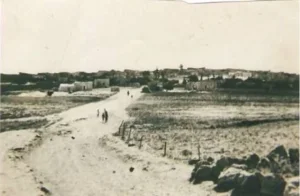
'Innaba stood on a rocky hill overlooking the coastal plain, approximately 7 km east of Ramla.
The village had an average elevation of about 125 metres above sea level.
It was situated less than 3 km northeast of the Jerusalem–Jaffa highway and was connected to it by a secondary road. Other secondary roads linked 'Innaba with neighbouring Palestinian villages.
The oldest part of the village was enclosed by a wall, and its principal entrance was linked with the Jaffa–Jerusalem highway.
Name and History of 'Innaba
Palestine Remembered suggests that the name 'Innaba may be connected with the Arabic word for the jujube tree, perhaps reflecting the former presence of such trees in the area. Khalidi's PalQuest entry does not present this as a confirmed etymology, so it is treated here as a possible local interpretation.
The village has been identified with the ancient locality of Betoannaba, which lay within the jurisdiction of Diospolis, or Lydda, during the Roman period.
In 1596, 'Innaba was a village in the nahiya of Ramla within the liwa of Gaza, with an estimated population of approximately 165.
Its inhabitants paid taxes on wheat, barley, olives, fruit, goats, beehives, and vineyards.
In the late nineteenth century, 'Innaba was described as a medium-sized village built of adobe on elevated ground and surrounded by olive trees.
Architecture of 'Innaba
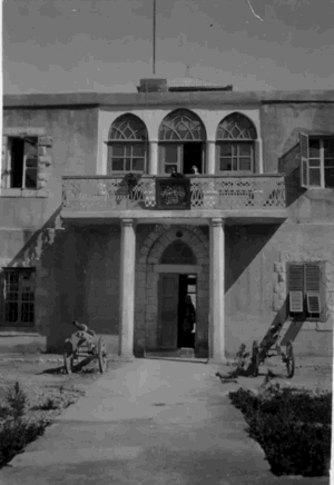
The older part of 'Innaba was enclosed by a wall. Its oldest houses were built of adobe, while most later dwellings were constructed of stone and clustered close together.
The houses surrounded a mosque dedicated to Shaykh Abd Allah and built around his shrine.
Beginning in the late 1930s, villagers constructed two- and three-storey houses. Building activity increased during the final years of the British Mandate and spread along roads leading to neighbouring villages and onto former agricultural land.
A partial ring of fig trees, olive trees, and grapevines surrounded the village.
Each hamula, or branch of a hamula, maintained a diwan that served as a communal gathering space in the evenings and on occasions such as weddings.
Education in 'Innaba
An elementary school was established in 'Innaba in 1920 near the shrine of Shaykh Isa.
By the mid-1940s, approximately 168 pupils attended the school.
In 1938, a new school was built after the old school site was sold. The new school acquired approximately ten dunums of land and also accepted pupils from neighbouring villages.
In 1948, approximately 150 pupils were enrolled.
The figures of 168 and 150 refer to different points in the school's development and should not be treated as a direct contradiction.
Public Services in 'Innaba
'Innaba served as a local centre for nearby villages such as al-Barriyya and al-Qubayba because it provided services unavailable in some surrounding communities.
The village contained a mosque, a school, a grain mill, twelve shops, and two coffeehouses.
It also had eleven lime-producing plants. Khalidi cites a local study reporting a combined output of approximately 500 tons of lime per day, with the product sold in a number of cities.
Economic Life in 'Innaba
Agriculture, particularly rainfed farming, and livestock raising were the principal sources of livelihood.
Some villagers travelled to Ramla to market agricultural produce, while others worked in the city.
Important crops included cereals, especially wheat, vegetables such as tomatoes and okra, citrus fruit, sesame, and olives.
In 1944/45, 111 dunums were devoted to citrus and bananas and 511 dunums were irrigated or used for plantations.
A total of 10,650 dunums was devoted to cereals: 10,626 Palestinian dunums, 21 dunums in the category “Transferred to Zionists,” and 3 communal/public dunums.
Palestine Remembered separately records 573 dunums planted with olive trees. This is retained as an additional agricultural figure but is not added again to the total cultivable area.
Land Ownership in 'Innaba
The total registered land area of 'Innaba was 12,857 dunums in the 1944/45 statistics.
Land ownership in 'Innaba, 1944/45, using the terminology of Palestine Remembered
- Palestinian12,244 dunums95%
- Transferred to Zionists21 dunums<1%
- Communal592 dunums5%
Land Use in 'Innaba, 1944/45
Land use in 'Innaba, separating ownership categories according to PalQuest's detailed statistics
- Palestinian
- Transferred to Zionists
- Communal/Public
- Citrus and bananas111 dunums
- Plantations and irrigable land511 dunums
- Cereals10,650 dunums
- Built-up area54 dunums
- Non-cultivable land1,531 dunums
A total of 11,272 dunums, approximately 88 percent of the village lands, was cultivated or cultivable: 11,248 Palestinian dunums, 21 dunums in the category “Transferred to Zionists,” and 3 communal/public dunums.
Built-up and non-cultivable land together amounted to 1,585 dunums, or approximately 12 percent of the total.
Palestine Remembered places 10,629 dunums of cereal land in its Palestinian column, whereas PalQuest's detailed statistics divide this into 10,626 Arab dunums and 3 public dunums. Likewise, the 1,531 dunums of non-arable land consist of 942 Arab dunums and 589 public dunums. The communal/public category is therefore separated above.
Population of 'Innaba
Population of 'Innaba in selected years
- 1596165Estimate derived from Ottoman records
- 1922863Official British Mandate census
- 19311,135Official census; includes al-Kunayyisa
- 1944/451,420Official statistics; all recorded inhabitants were Arab
- 19481,647Later estimate published by Palestine Remembered
- Estimated refugees in 199810,116Later estimate published by Palestine Remembered
Number of Houses in 'Innaba
Number of houses in 'Innaba
- 1931288Official census figure; includes al-Kunayyisa
- 1948417Later estimate published by Palestine Remembered
The Attack on 'Innaba during Operation Yoram
'Innaba was first subjected to a major attack on 8–9 June 1948 during Operation Yoram, one of the military attempts associated with the battle for the al-Latrun area.
The Yiftach Brigade carried out the attack on 'Innaba as a diversion from the main effort against al-Latrun.
The village was not occupied during this operation, but the attack prompted the villagers to evacuate women and children in anticipation of further fighting.
The original Israeli military account concerning Operation Yoram is not used independently here; it is included only because it is reproduced in Khalidi's approved Palestinian reference.
Operation Dani and the Occupation of 'Innaba
Operation Dani began on 9 July 1948 and targeted Lydda, Ramla, and the surrounding villages and communication routes.
'Innaba was among the villages directly affected by the operation.
The final attack on the village took place on 10 July 1948. Women and children had already been evacuated after the earlier attacks, leaving approximately 200 men in the village.
Israeli occupation forces attacked 'Innaba from three directions while leaving an escape route open toward the northeast.
The village defenders were poorly armed and resisted until their ammunition was exhausted. Shortly after 1:00 a.m., they withdrew toward the northeast.
The Yiftach and Eighth brigades are identified with the occupation and subsequent destruction of the village.
The Arabic PalQuest entry contains a typographical error giving “10 September,” while the English version of the same entry clearly states 10 July. The July date is also consistent with Operation Dani and with Palestine Remembered's occupation date.
- First major attack: 8–9 June 1948.
- First operation: Operation Yoram.
- Unit involved in the first attack: Yiftach Brigade.
- Final occupation date: 10 July 1948.
- Military operation: Operation Dani.
- Units associated with the occupation and demolition: Yiftach and Eighth brigades.
- Men remaining before the final assault: approximately 200.
- Fate of the population: women and children were evacuated after the earlier attacks; the remaining defenders withdrew after exhausting their ammunition.
Destruction of 'Innaba
On 10 July 1948, the same day the village was occupied, Israeli army headquarters ordered the systematic demolition of 'Innaba's houses.
The Yiftach and Eighth brigades were instructed to demolish most of the village, leaving only nine buildings to house a small military garrison.
Those nine structures survived until 1952, when the Israeli army dynamited and bulldozed them as well.
The destruction of 'Innaba therefore occurred in two stages: extensive demolition immediately after the July 1948 occupation, followed by the removal of the remaining buildings in 1952.
Settlement Established on the Lands of 'Innaba
Kefar Shemu'el was established on the lands of 'Innaba in 1950.
The settlement was named after the American Zionist leader Stephen “Shemu'el” Wise.
- Kefar Shemu'el: established in 1950 on 'Innaba's lands.
'Innaba Today
According to the field description published by Walid Khalidi in All That Remains, the site of 'Innaba was fenced and difficult to enter. It overlooks the Jerusalem–Tel Aviv highway a few kilometres from al-Latrun.
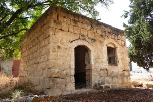
Heaps of rubble covered the site and were overgrown with grasses, wild vegetation, cactus plants, and surviving olive and Christ's-thorn trees dating from before the Nakba.
The remains of the village school and the local headquarters of the Arab Palestine Party were visible among the ruins of the houses.
Parts of the cemetery remained identifiable, together with surviving trees and traces of old Palestinian orchards containing olives, pomegranates, and cactus.
A deserted well also remained in the area formerly known as al-Attan, with a pile of stones surrounding its opening.
The surrounding lands were under cultivation at the time of Khalidi's field documentation.
Palestine Remembered contains later user-contributed photographs, videos, oral histories, and visits, including material added in August 2026. The site itself cautions that user contributions reflect their contributors and are not guaranteed to be fully accurate.
The principal description above therefore relies on Khalidi's field research published in 1992. The approved sources used here do not provide a sufficiently comprehensive and independent contemporary survey to verify the precise condition of every part of 'Innaba in 2026.
Sources
Photo gallery


Photos from the village's people
Photos sent in by visitors and published after review.
Add a photo of this village
Log in to add photos of this village.
Other villages from Ramla
More from the archive



 Download Our Palestine App
The whole archive in the palm of your hand: depopulated villages, the Nakba, the massacres and Al-Aqsa — free, with no ads to erase the story.
Download Our Palestine App
The whole archive in the palm of your hand: depopulated villages, the Nakba, the massacres and Al-Aqsa — free, with no ads to erase the story.



Comments
No comments yet — be the first to write one.
Add your comment
Name and email are optional. Comments appear after review.