
The depopulated village of Zarnuqa / District of Ramla

Zarnuqa
About the depopulated village of Zarnuqa
- District
- Ramla
- Date Zarnuqa was occupied
- 27 May 1948
- Population in 1948
- 2,760
- Military operation
- Operation Barak
- Brigade that carried it out
- Givati Brigade
- Elevation above sea level
- 50 m
- Cause of displacement
- Expulsion by Zionist troops
- Extent of destruction
- In June 1948, Zarnuqa was mostly destroyed with the exception of few houses remain standing.
- Ethnic cleansing
- Zarnuqa inhabitants were completely ethnically cleansed.
- Settlements built on the land of Zarnuqa before 1948
- Gan Shelomo, Gibton, Giv'at Brenner
- Settlements built on the built-up area of Zarnuqa after 1948
- Gan Shelomo
Hover a dot to read the village name, or click to open its card.
Borders of the depopulated village of Zarnuqa
Zarnuqa: A Depopulated Palestinian Village in the Ramla District
Zarnuqa was a Palestinian village in the Ramla District, located approximately 10 km southwest of Ramla on flat land in the central coastal plain, at an average elevation of about 50 metres above sea level. Its Palestinian inhabitants were displaced during the Nakba and the occupation of Palestine in 1948. Giv'ati Brigade forces occupied the village on 27 May 1948 in the context of Operation Barak, and most of its built-up area was destroyed in June.
Location of Zarnuqa
Zarnuqa stood on flat terrain in the central coastal plain, approximately 10 km southwest of Ramla and at an average elevation of about 50 metres above sea level.
A secondary road connected the village with the main road leading to Ramla, while the surrounding road network linked it with neighbouring villages and towns.
Nearby Palestinian localities included 'Aqir, Yibna, al-Maghar, and al-Qubayba, together with other settlements and localities in the surrounding area.
The village depended mainly on wells for water. Wells and orchards were particularly concentrated to the north and northwest.
The Name Zarnuqa
Palestine Remembered states that the name Zarnuqa is a corruption of the Arabic word “zarnuq,” which it interprets as meaning a small stream.
Walid Khalidi's PalQuest entry does not provide an etymology for the name. This interpretation is therefore presented as an explanation given by Palestine Remembered rather than as a conclusively established linguistic origin.
Architecture of Zarnuqa
In the late nineteenth century, Zarnuqa was an adobe-built village surrounded by gardens enclosed with cactus hedges.
The village had a roughly trapezoidal layout, with its western side forming the long base of the trapezoid. Construction accelerated during the final years of the British Mandate as the local economy prospered.
The expansion of the built-up area was closely associated with the growth of agriculture, particularly citrus cultivation.
Zarnuqa's Palestinian Arab inhabitants were Muslim. The village had a mosque and public facilities that included a medical clinic and two elementary schools.
Education in Zarnuqa
A boys' elementary school was established in 1924 and became a full elementary school in 1942.
The school included six dunums of land used to train pupils in scientific agriculture, poultry raising, and beekeeping.
Walid Khalidi's PalQuest entry records approximately 252 boys enrolled by the mid-1940s.
A girls' elementary school was established in 1943 with an initial enrolment of 65 pupils.
Palestine Remembered's statistical summary gives different figures for 1945: 242 boys and 45 girls. Since the figures refer to somewhat different dates and differ between the source's summary and Khalidi's detailed account, both are retained rather than merged into a single figure.
Economic Life in Zarnuqa
Agriculture formed the backbone of the village economy, with fruit and especially citrus cultivation playing a major role.
Citrus groves and other fruit trees surrounded Zarnuqa and were irrigated from wells. Orchards and wells were most numerous north and northwest of the village.
In 1944/45, a total of 3,085 dunums was devoted to citrus and bananas: 2,070 Palestinian dunums and 1,015 dunums in the category “Transferred to Zionists.”
Another 1,202 dunums were irrigated or used for plantations, consisting of 1,189 Palestinian dunums and 13 dunums in the category “Transferred to Zionists.”
A total of 2,759 dunums was devoted to cereals.
Palestine Remembered records 10 dunums of Palestinian olive groves. This figure forms part of the wider plantation and agricultural categories and should not be added again to the total cultivable land.
A weekly market was held every Saturday and served merchants arriving from Jaffa, Lydda, and Ramla.
Land Ownership in Zarnuqa
The total registered land area of Zarnuqa was 7,545 dunums in the 1944/45 statistics. PalQuest notes that these figures include Gibton.
Land ownership in Zarnuqa, 1944/45, using the terminology of Palestine Remembered
- Palestinian5,640 dunums75%
- Transferred to Zionists1,578 dunums21%
- Communal327 dunums4%
The land recorded under the category “Transferred to Zionists” represented approximately 20.9 percent of the total area in the 1944/45 statistics.
Land Use in Zarnuqa, 1944/45
Land use in Zarnuqa, separating ownership categories according to PalQuest's detailed statistics
- Palestinian
- Transferred to Zionists
- Communal/Public
- Citrus and bananas3,085 dunums
- Plantations and irrigable land1,202 dunums
- Cereals2,759 dunums
- Built-up area68 dunums
- Non-cultivable land431 dunums
A total of 7,046 dunums, approximately 93 percent of the registered land, was cultivated or cultivable: 5,525 Palestinian dunums and 1,521 dunums in the category “Transferred to Zionists.”
Built-up and non-cultivable land together amounted to 499 dunums, or about 7 percent of the total.
Palestine Remembered presents 374 dunums of non-arable land in its Palestinian column. PalQuest's detailed statistics show that this consists of 47 Arab dunums and 327 public dunums. A further 57 non-cultivable dunums were recorded in the Jewish category of the original statistics. The communal/public category is therefore separated above.
Population of Zarnuqa
Population of Zarnuqa in selected years
- 19311,952Official British Mandate census
- 1944/452,620Official statistics including Gibton: 2,380 Arabs and 240 Jews
- 19482,761Later Palestine Remembered estimate; the source includes 240 Jews in this total
- Estimated refugees in 199816,954Later estimate published by Palestine Remembered
The official 1944/45 Arab population was 2,380. The larger total of 2,620 includes 240 Jews and, according to PalQuest, also includes Gibton.
Number of Houses in Zarnuqa
Number of houses in Zarnuqa
- 1931414Official British Mandate census figure
- 1948585Later estimate published by Palestine Remembered
Archaeological Remains in Zarnuqa
Some secondary material refers to archaeological localities on Zarnuqa's lands containing pottery fragments and graves. The principal Khalidi/PalQuest entry and Palestine Remembered's main village file, however, do not provide sufficiently detailed documentation of these sites.
No specific archaeological period or site identification is therefore presented as established fact without stronger evidence from the approved sources.
Operation Barak and the Occupation of Zarnuqa
The occupation of Zarnuqa was associated with Operation Barak, an offensive conducted primarily by the Haganah's Giv'ati Brigade against Palestinian villages south and west of Ramla in May 1948.
PalQuest's operation page formally dates Operation Barak from 9 to 13 May, but its narrative also describes a second stage after the British withdrawal on 15 May and states that Giv'ati and Negev Brigade forces continued occupying villages through the end of the month.
PalQuest further states that one of the declared objectives of the operation was the expulsion of large numbers of Palestinians from occupied areas and that residents remaining in villages after capture were liable to expulsion.
Occupation and Depopulation of Zarnuqa during the Nakba
Giv'ati Brigade troops occupied Zarnuqa on 27 May 1948 during the later phase of Operation Barak.
Walid Khalidi describes the village as “semi-abandoned” at the time of occupation, relying on an account by Israeli historian Benny Morris.
The occupation itself, however, was accompanied by serious abuses documented in a letter published in the Mapam newspaper Al ha-Mishmar and reproduced in Khalidi's village entry.
The account states that a soldier fired a Sten gun at an elderly man, a woman, and a child inside one house. Palestinians remaining in the village were then removed from their homes and forced to stand for hours in the sun without food or water while soldiers demanded weapons.
The remaining Palestinian inhabitants were eventually expelled from Zarnuqa in the direction of Yibna.
The New York Times, citing Israeli sources at the time, reported that Zarnuqa and al-Qubayba were occupied after approximately four hours of fighting.
After the occupation, village houses were also looted and vandalized by troops and residents of neighbouring settlements, according to the account reproduced by Khalidi.
The Israeli sources referred to above are not used independently here; their accounts are included only because they are reproduced and discussed in the approved Palestinian reference.
- Occupation date: 27 May 1948.
- Military operation: Operation Barak.
- Attacking unit: Giv'ati Brigade.
- Length of fighting according to a contemporary press report: approximately four hours.
- Fate of the remaining inhabitants: expelled toward Yibna.
- Abuses recorded during the occupation included the killing of civilians and forcing villagers to stand for hours in the sun, according to an account reproduced by Khalidi.
- Village houses were looted and vandalized after the occupation.
Destruction of Zarnuqa
Zarnuqa was extensively destroyed in June 1948, only weeks after its occupation and the expulsion of its Palestinian inhabitants.
In August 1948, nearby Kvutzat Schiller applied to Zionist settlement authorities for part of Zarnuqa's lands to be permanently transferred to it.
The source does not establish whether this request was formally approved.
By 27 May 1949, new Jewish immigrants had been settled at the site of the destroyed village.
Settlements Established or Expanded onto Zarnuqa's Lands
The settlement of Zarnoqa was established in late 1948 on the Palestinian village site itself and later became part of the urban outskirts of Rehovot.
Several settlements founded before the Nakba also subsequently expanded onto portions of Zarnuqa's lands:
- Zarnoqa: established in late 1948 on the village site.
- Gan Shelomo: originally established in 1927 and later expanded onto part of Zarnuqa's lands.
- Gibton: established in 1933 and later spread onto village lands.
- Giv'at Brenner: established in 1928 and later expanded onto portions of Zarnuqa's lands.
A second settlement named “Oub” or similar in some secondary material could not be verified in the principal approved sources used here and is therefore not included.
Zarnuqa Today
According to the field description published by Walid Khalidi in All That Remains, buildings belonging to Israeli settlements came to dominate the former village site, while mulberry trees and cactus plants grew in parts of it.
A small number of Palestinian village houses remained standing at the time of Khalidi's documentation. Some were occupied by Jewish residents, while others were fenced and used for storage.
Khalidi described one surviving concrete house as having a broad roofed porch supported by two columns.
The surrounding lands were used for agriculture.
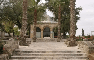
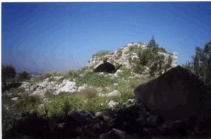
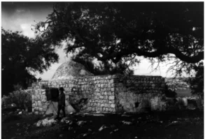
Palestine Remembered contains later user-contributed photographs, including images from 1999 and 2002 showing a mosque and other village remains. Some user captions state that the mosque was being used as a synagogue at that time. These contributions are not a comprehensive independent contemporary field survey.
The principal field description therefore derives from research published in Khalidi's 1992 volume. The approved sources used here do not provide a sufficiently comprehensive and independent recent survey to verify the precise condition and use of every surviving building and parcel of Zarnuqa in 2026.
Sources
- PalQuestPalQuest – Interactive Encyclopedia of the Palestine Question: Zarnuqa
- PalQuestPalQuest – Operation Barak
- Palestine RememberedPalestine Remembered – Zarnuqa, Ramla District
- Palestine RememberedPalestine Remembered – Zarnuqa entry from All That Remains
- Institute for Palestine StudiesInstitute for Palestine Studies – All That Remains, Walid Khalidi
Photo gallery


Photos from the village's people
Photos sent in by visitors and published after review.
Add a photo of this village
Log in to add photos of this village.

More from the archive


 Download Our Palestine App
The whole archive in the palm of your hand: depopulated villages, the Nakba, the massacres and Al-Aqsa — free, with no ads to erase the story.
Download Our Palestine App
The whole archive in the palm of your hand: depopulated villages, the Nakba, the massacres and Al-Aqsa — free, with no ads to erase the story.



Comments
No comments yet — be the first to write one.
Add your comment
Name and email are optional. Comments appear after review.