
The depopulated village of Bayt Susin / District of Ramla
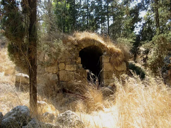
Bayt Susin
About the depopulated village of Bayt Susin
- District
- Ramla
- Date Bayt Susin was occupied
- 30 May 1948
- Population in 1948
- 240
- Brigade that carried it out
- The Seventh Brigade
- Distance from the governorate centre
- 17 (km) Southeast of al-Ramla
- Elevation above sea level
- 300 m
- Cause of displacement
- Military assault by Zionist troops
- Extent of destruction
- The village was completely obliterated, and only house rubble left behind.
- Ethnic cleansing
- On April 20th, 1948, Bayt Susin was ethnically cleansed during Operation Nachshon.
Hover a dot to read the village name, or click to open its card.
Borders of the depopulated village of Bayt Susin
Bayt Susin – Depopulated Palestinian Village of the Ramla Subdistrict
Bayt Susin was a depopulated Palestinian village in the Ramla Subdistrict, located approximately 17 kilometers southeast of Ramla. It stood on a hilltop on the southern slopes of a mountainous area at an average elevation of about 300 meters above sea level.
The village overlooked broad areas to the west and south. Two watercourses descended the slopes and met below the village. Bayt Susin was also located near a network of roads serving several urban centers, while a secondary road connected it with the main Jaffa–Jerusalem highway.
- District
- Ramla
- Distance from Ramla
- Approximately 17 km southeast of Ramla
- Elevation
- Approximately 300 m above sea level
- Natural Setting
- A hilltop on the southern slopes of a mountainous area, overlooking the west and south, with two watercourses meeting below the village
- Population in 1944/1945
- 210 inhabitants
- Estimated Population in 1948
- 244 inhabitants – a later estimate, not an official census
- Occupation and Depopulation Period
- A failed assault on 22–23 May 1948; final occupation on 28 or 30 May according to differing sources
- Military Operation
- Operation Ben-Nun in the context of the battles for al-Latrun; an earlier account links the village to Operation Nachshon in April
- Military Unit
- Sheva' / Seventh Brigade
- Total Land Area
- 6,481 dunums
- Israeli Settlement Established on Village Lands
- Ta'oz, established in 1950
Bayt Susin Through History
Crusader sources referred to the village as Bezezin. In 1596, Bayt Susin belonged to the nahiya of Ramla in the liwa' of Gaza. Walid Khalidi's account, as reproduced by PalQuest, gives an estimated population of 308 and records taxes on wheat, barley, olives, goats, beehives, and other agricultural products.
Edward Robinson passed through Bayt Susin in 1852 and described it as a small and ancient village. During the British Mandate period, the Palestine Index Gazetteer classified Bayt Susin as a hamlet.
Location and Built Environment
Bayt Susin stood on a hilltop overlooking the countryside to its west and south. Its built-up area was divided into two sections. The larger section had a rectangular plan running from north to south, while the smaller section stood about 250 meters to the southwest.
The houses were constructed of stone. A mosque stood near the smaller section, and the villagers obtained water for domestic use from a spring in or near the village.
Population of Bayt Susin
- 1596308Historical figure derived from Ottoman-period records as reproduced by later sources; not a modern census
- 192247Official Census of Palestine, 1922
- 193170Official Census of Palestine, 1931
- 1944/1945210Official British Mandate statistics
- 1948244Later estimate published by Palestine Remembered; not an official census
- 19981,496 refugeesLater estimate of refugees and descendants; not an official village census
Number of Houses
- 193114 occupied housesOfficial census
- 194848 housesLater estimate published by Palestine Remembered
Land Ownership in Bayt Susin
Bayt Susin had a total land area of 6,481 dunums. Palestine Remembered presents the simplified ownership categories as follows:
- Palestinian5,453 dunums84%
- Transferred to Zionists0 dunums0%
- Communal/Public1,028 dunums16%
The official 1944/45 land statistics classify the same area as 5,453 Arab dunums and 1,028 public dunums, with no land listed under Jewish ownership.
Land Use in 1944/1945
- Arab
- Public
- Cereals5,115 dunums
- Plantations and Irrigable Land94 dunums
- Built-up Area8 dunums
- Non-Cultivable Land1,264 dunums
A total of 5,209 dunums was classified as cultivable or cultivated land, representing approximately four-fifths of the village territory.
Economic Life in Bayt Susin
The village economy depended primarily on agriculture and animal husbandry. Cereals constituted the principal crop, with 5,115 dunums classified under cereal cultivation in the 1944/45 land-use statistics.
A further 94 dunums consisted of plantations and irrigable land. The historical account also records olive trees on approximately two dunums in 1943. Livestock raising formed another important component of the village economy.
Water Resources
Residents obtained domestic water from a spring in or near the village. Historical geographical descriptions also refer to two watercourses descending the slopes and meeting below the village site.
Education in Bayt Susin
In 1947, residents of Bayt Susin and neighboring Bayt Jiz jointly financed a school that served children from both villages. The school was associated physically with Bayt Jiz but was shared by the two communities.
The Mosque and Religious Life
Bayt Susin had a mosque near the smaller section of the village, and its population was predominantly Muslim. The principal historical sources reviewed here do not independently verify the existence of a church, so an isolated database entry referring to one has not been treated as sufficient evidence.
Archaeological Remains and Khirbas
Several khirbas and archaeological sites near Bayt Susin contained the remains of walls and building foundations, cut stones, rock-hewn cisterns, caves, a basin, and burial grounds. The principal sources do not provide enough evidence to assign a precise period to all of these remains.
Occupation and Depopulation of Bayt Susin
The sources differ over the date of Bayt Susin's occupation, and it is important to distinguish an April account from the more detailed military chronology of May 1948.
Walid Khalidi reproduces an account attributed to Israeli historian Benny Morris according to which Bayt Susin was occupied and depopulated on 20 April 1948 in the aftermath of Operation Nachshon. Khalidi, however, also discusses other evidence that conflicts with this date.
Palestinian historian 'Arif al-'Arif states that an attempt to capture Bayt Susin on 22–23 May failed after the attacking force encountered unexpectedly strong resistance from local inhabitants and Arab forces in the al-Latrun sector.
Al-'Arif places the final occupation approximately one week later, on either 28 or 30 May, during the battles around al-Latrun. Another account reproduced by Khalidi indicates that the Sheva' or Seventh Brigade captured Bayt Susin and neighboring Bayt Jiz during this phase, while the capture of the two villages was announced on 28 May.
PalQuest explicitly links the fall of Bayt Susin and Bayt Jiz to Operation Ben-Nun, part of the military effort around al-Latrun and the attempt to establish an alternative supply route between the coastal area and forces in Jerusalem.
Occupation Chronology
- 20 April 1948
Account of an Earlier Occupation
An account reproduced by Khalidi and attributed to Benny Morris links the occupation and depopulation of Bayt Susin to the aftermath of Operation Nachshon; this conflicts with the detailed May chronology.
- 22–23 May 1948
Failed Assault
'Arif al-'Arif records an unsuccessful attempt to capture the village after the attacking forces encountered resistance from local inhabitants and Arab forces.
- 28 or 30 May 1948
Final Occupation
Al-'Arif places the fall of Bayt Susin on one of these dates; the capture of Bayt Susin and Bayt Jiz was announced on 28 May.
- Late May 1948
Military Operation
Bayt Susin and Bayt Jiz fell to the Sheva' / Seventh Brigade in the context of Operation Ben-Nun and the battles for al-Latrun.
- After occupation; precise date unknown
Destruction
The sources do not establish a precise demolition date, but later field documentation records that most of the site had been leveled.
Military Operation and Unit
Military Operation: Operation Ben-Nun, in the context of attempts to capture the al-Latrun area and establish an alternative supply route toward Jerusalem. An earlier account associates Bayt Susin with Operation Nachshon in April, but this conflicts with the later chronology of a failed assault on 22–23 May followed by the village's final occupation at the end of the month.
Military Unit: Sheva' / Seventh Brigade. The principal sources identify the brigade in connection with the capture of Bayt Susin and Bayt Jiz together; a specific battalion is therefore not stated here without independent village-level verification.
Cause of Depopulation
The depopulation of Bayt Susin was connected to the military assaults in the al-Latrun sector. Palestine Remembered classifies the cause as a direct military assault, while the historical chronology documents failed and subsequent attacks culminating in the occupation of the village in late May 1948.
Destruction of Bayt Susin
The precise date on which Bayt Susin was destroyed is not known. Historical material reproduced by Khalidi notes that many villages captured in the Jerusalem corridor during this period were subsequently leveled, while later field documentation confirms that most of Bayt Susin's built-up area had been bulldozed.
Israeli Settlement on Bayt Susin Village Lands
The moshav of Ta'oz was established in 1950 on Bayt Susin's lands, southeast of the former village site.
Bayt Susin Today
According to the field documentation used by Walid Khalidi, with photographs published by PalQuest dated June 1990, the village site had been largely bulldozed and leveled. Grass and thorns covered the remaining rubble.
Traces of a fig tree remained visible near the center of the site, while fragments of house walls survived along the southern edge among carob, pine, and cedar trees. Cactuses and bushes grew along the northwestern edge, and the areas to the north and east had been planted with trees.
This description reflects historical field documentation from 1990, preceding the publication of All That Remains in 1992. It should therefore not be treated as a direct field verification of conditions at the site in 2026.
Sources
- PalQuest – Interactive Encyclopedia of the Palestine Question: Bayt Susin.
- PalQuest – Bayt Jiz, particularly the material on Operation Ben-Nun and the capture of Bayt Susin and Bayt Jiz.
- Palestine Remembered – Bayt Susin, Ramla District.
- Walid Khalidi, All That Remains: The Palestinian Villages Occupied and Depopulated by Israel in 1948.
- 'Arif al-'Arif, material on the battles around al-Latrun and Bayt Susin as reproduced by Khalidi and PalQuest.
- Government of Palestine, Census of Palestine, 1922.
- E. Mills, Census of Palestine 1931: Population of Villages, Towns and Administrative Areas.
- Government of Palestine, Village Statistics, 1945, reproduced by Sami Hadawi.
Photo gallery


Photos from the village's people
Photos sent in by visitors and published after review.
Add a photo of this village
Log in to add photos of this village.
Other villages from Ramla
More from the archive



 Download Our Palestine App
The whole archive in the palm of your hand: depopulated villages, the Nakba, the massacres and Al-Aqsa — free, with no ads to erase the story.
Download Our Palestine App
The whole archive in the palm of your hand: depopulated villages, the Nakba, the massacres and Al-Aqsa — free, with no ads to erase the story.



Comments
No comments yet — be the first to write one.
Add your comment
Name and email are optional. Comments appear after review.