
The depopulated village of Al-Mukhayzin / District of Ramla
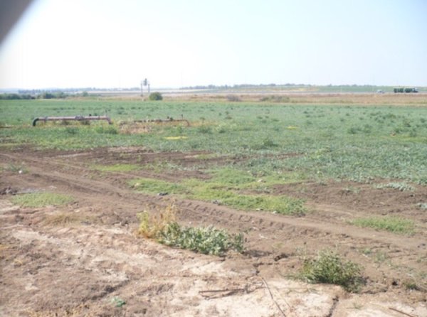
Al-Mukhayzin
About the depopulated village of Al-Mukhayzin
- District
- Ramla
- Date Al-Mukhayzin was occupied
- 20 April 1948
- Population in 1948
- 230
- Military operation
- Operation Nachshon
- Brigade that carried it out
- Givati Brigade
- Distance from the governorate centre
- 10 (km) Southwest of al-Ramla
- Elevation above sea level
- 75 m
- Cause of displacement
- Military assault by Zionist troops
- Extent of destruction
- al-Mukhayzin was completely obliterated and defaced soon after occupation.
- Ethnic cleansing
- al-Mukhayzin inhabitants were completely ethnically cleansed.
Hover a dot to read the village name, or click to open its card.
Borders of the depopulated village of Al-Mukhayzin
Al-Mukhayzin – Depopulated Palestinian Village of the Ramla Subdistrict
Al-Mukhayzin was a Palestinian village in the Ramla Subdistrict, situated on level ground in the southern coastal plain. PalQuest places it approximately 15 kilometers from Ramla, at an average elevation of about 75 meters above sea level.
A tributary of Wadi al-Sarar ran along the eastern side of the village. A dirt road approximately three kilometers long connected al-Mukhayzin with the main Jerusalem–Gaza road, while other tracks linked it with neighboring Palestinian villages.
- Subdistrict
- Ramla
- Historical Administrative Classification
- Lydda District / Ramla Subdistrict in PalQuest's classification
- Distance from Ramla
- Approximately 15 km according to PalQuest; Palestine Remembered gives approximately 10 km
- Direction
- Southwest of Ramla
- Average Elevation
- 75 meters
- Population in 1931
- 79, all Muslims, living in 19 houses
- Arab Population in 1944/1945
- 200
- Jewish Population within the Statistical Unit in 1944/1945
- 110
- Total Statistical-Unit Population in 1944/1945
- 310
- Estimated Arab Population in 1948
- 232 according to Salman Abu Sitta – a later estimate, not an official 1948 census
- Total Land Area
- 12,548 dunums
- Occupation / Depopulation Date
- 20 April 1948 in Khalidi's account; Salman Abu Sitta records 19 April
- Military Operation
- Jerusalem corridor operations; Operation Har'el is the strongest immediate context if the 20 April date is accepted
- Military Unit
- Not conclusively established; Palestine Remembered attributes the attack to the Giv'ati Brigade
- Cause of Displacement
- Military assault and takeover of the village during operations aimed at securing the route between the coast and Jerusalem
- Extent of Destruction
- The village was largely leveled; no reliable numerical destruction percentage is available
- Settlement on Village Land before 1948
- Chafetz Chayyim – 1944
- Post-1948 Settlements on Village Land
- Revadim – 1948; Yad Binyamin – 1949; Beyt Chilqiyya – 1953
Origin of the Name
Al-Mukhayzin began as a cluster of grain-storage structures built by a group belonging to the Arab al-Wuhaydat tribe.
The village name derives from this function: al-Mukhayzin is a diminutive form of the Arabic word for storehouse or warehouse.
Arab al-Wuhaydat and the Establishment of the Village
The historic Palestinian community of al-Mukhayzin was associated with Arab al-Wuhaydat, whose members established the early grain stores and settled at the site.
As settlement developed, a small village grew around them. Most houses were constructed of adobe, although some were built of stone and cement.
The Palestine Index Gazetteer classified al-Mukhayzin as a hamlet or agricultural settlement during the Mandate period.
Location and Roads
Al-Mukhayzin stood on flat terrain in Palestine's southern coastal plain, with a branch of Wadi al-Sarar passing beside its eastern edge.
A three-kilometer dirt road connected the village to the Jerusalem–Gaza highway, and additional tracks connected it to neighboring villages.
Its proximity to routes linking the coast and Jerusalem later contributed to its strategic importance during the 1948 fighting.
Village Layout and Houses
The village had a rectangular plan and extended toward the northwest.
It remained relatively small; the official 1931 census recorded 19 occupied houses.
Most dwellings were built of adobe, with some stone-and-cement construction.
Population in 1931
The official 1931 Census of Palestine recorded 79 inhabitants in al-Mukhayzin, all Muslims, living in 19 houses.
- 193179Official Census of Palestine; all inhabitants were Muslims
- 1944/1945200 ArabsThe Palestinian population of the village within the statistical unit
- 1944/1945110 JewsJewish population within the al-Mukhayzin statistical land unit
- 1944/1945310 totalCombined Arab and Jewish population of the statistical unit; not the Palestinian village population alone
- 1948232 ArabsLater estimate in Salman Abu Sitta's Register, not an official census
Correcting the 310 Population Figure
Some later sources state simply that al-Mukhayzin had 310 inhabitants in 1945.
The 1944/45 statistics, however, divide this figure into 200 Arabs and 110 Jews.
The Palestinian village population was therefore 200, while 310 represents the total population of the larger statistical unit that also included Jewish residents associated with land on which Chafetz Chayyim had been established.
Estimated Population in 1948
Salman Abu Sitta's Register gives an estimated 232 Arab inhabitants for al-Mukhayzin in 1948.
This is a retrospective demographic estimate, not a census conducted in 1948.
Later Palestinian refugee statistics reproduced by Palestine Remembered give an estimated 1,425 refugees and descendants in 1998 originating from al-Mukhayzin.
Land Ownership in 1944/1945
The complete al-Mukhayzin statistical land unit covered 12,548 dunums.
- Arab10,942 dunums87%
- Jewish1,380 dunums11%
- Public226 dunums2%
The official statistical categories are Arab, Jewish, and Public.
The Palestinian Encyclopedia separately describes the 1,380 dunums as land that had “transferred to Zionists.” The distinction between the official statistical terminology and the encyclopedia's wording is retained here.
Land Use in 1944/1945
- Arab
- Jewish
- Public
- Cereals12,316 dunums
- Non-Cultivable232 dunums
Approximately 12,316 dunums—about 98 percent of the statistical land unit—were classified as cultivated or cultivable cereal land.
Economic Life
The villagers depended primarily on rain-fed agriculture.
Cereal cultivation was the dominant activity, supplemented by vegetables and fruit trees.
The more than ten thousand Arab-owned dunums devoted to cereals illustrate the strongly agricultural character of al-Mukhayzin before the Nakba.
Water and Services
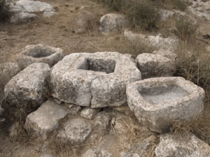
Al-Mukhayzin stood on an archaeological site containing a well, a pool, cisterns, architectural remains, and pottery fragments.
The principal sources do not record a substantial set of public institutions in the village, which remained a small rural agricultural settlement.
Archaeological Site
The village was built over an older site containing a well, an artificial pool, architectural fragments, and pottery remains.
These features indicate earlier settlement or use of the location before the modern village established by Arab al-Wuhaydat.
Chafetz Chayyim before the Nakba
Chafetz Chayyim was established in 1944 on land traditionally regarded as belonging to al-Mukhayzin.
This explains the presence of 110 Jewish residents within the 1944/45 statistical unit and 1,380 dunums in the Jewish ownership category.
Chafetz Chayyim should therefore not be described as a post-1948 settlement; it was already present on village land before the Nakba.
The Attack on al-Mukhayzin
The principal sources do not provide a complete operational account of every stage of the attack on al-Mukhayzin.
Walid Khalidi suggests that the village may have been occupied during one of the operations that followed Operation Nachshon in the Jerusalem corridor, as Zionist forces attempted to secure the route connecting Jerusalem with the coast.
The occupation date cited by Khalidi from Benny Morris is 20 April 1948.
This date falls during the phase known as Operation Har'el, which immediately followed Operation Nachshon.
Operation Nachshon and Operation Har'el
Operation Nachshon began on 3 April 1948 and continued until 15 April, with the objective of opening and securing the Tel Aviv–Jerusalem road.
PalQuest includes al-Mukhayzin among the localities affected during this wider campaign.
Operation Har'el followed between 16 and 21 April and continued military operations intended to secure the Jerusalem corridor.
If the 20 April occupation date is accepted, al-Mukhayzin's final capture falls chronologically within the Har'el phase.
Difference over the Occupation Date
The principal sources differ by one day:
- Walid Khalidi, citing the date given by Benny Morris: 20 April 1948.
- Salman Abu Sitta's Register: 19 April 1948.
Both nevertheless place the fall of al-Mukhayzin in the same late-April Jerusalem-corridor campaign immediately following Operation Nachshon.
Military Unit
Khalidi's al-Mukhayzin entry does not conclusively identify the particular unit that entered the village.
Palestine Remembered attributes the attack to the Giv'ati Brigade.
This attribution requires qualification: Giv'ati participated in Operation Nachshon, while the widely cited 20 April occupation date falls within the Operation Har'el phase.
The most accurate formulation is therefore:
Military unit: not conclusively established; Palestine Remembered attributes the attack to the Giv'ati Brigade, while the occupation chronology places the final capture within the Har'el operational phase.
Cause of Displacement
Palestinian documentation records a military assault as the cause of depopulation, within operations aimed at securing the Jerusalem corridor and the road linking the coast with Jerusalem.
Khalidi's account does not provide a detailed independent narrative of what happened to every family when the village fell.
The article therefore limits itself to the documented conclusion that the village was depopulated in the course of military assault and takeover in April 1948.
Occupation Chronology
- Until 1948
Al-Mukhayzin before the Nakba
A small Arab al-Wuhaydat agricultural village dependent primarily on rain-fed cereal cultivation and connected with the Jerusalem–Gaza road.
- 3–15 April 1948
Operation Nachshon
A major offensive began to open the Jerusalem corridor; PalQuest lists al-Mukhayzin among affected localities.
- 16 April 1948
Beginning of Operation Har'el
Operations aimed at consolidating control of the corridor continued after Nachshon.
- 19 April 1948
Abu Sitta Occupation Date
This is the date recorded in Salman Abu Sitta's Register.
- 20 April 1948
Khalidi/Morris Occupation Date
The most widely reproduced date; chronologically it places the village's final capture within Operation Har'el.
- After occupation
Destruction
The village was subsequently leveled; the sources used do not establish a separate precise demolition date.
Extent of Destruction
Al-Mukhayzin was extensively destroyed after its inhabitants were displaced.
Khalidi's field description states that the village was leveled so thoroughly that the original built-up area was replaced by cultivated and plowed fields, with only a mound of stone and rubble remaining at the southern edge.
No reliable numerical destruction percentage exists, so the article does not assign an unsupported figure such as 100 percent.
Settlements on al-Mukhayzin Land
A distinction must be made between the settlement established before the Nakba and those established after the Palestinian village was depopulated:
| Settlement | Year | Note |
|---|---|---|
| Chafetz Chayyim | 1944 | Established before the Nakba on land traditionally considered part of al-Mukhayzin |
| Revadim | 1948 | Established on al-Mukhayzin land after the village's depopulation |
| Yad Binyamin | 1949 | Established on village land |
| Beyt Chilqiyya | 1953 | Established on village land |
Al-Mukhayzin Today
The surviving-site description available for al-Mukhayzin derives from historical fieldwork incorporated into Walid Khalidi's All That Remains and should not be treated as direct 2026 field verification.
According to that description, the village had been leveled, leaving mainly cultivated and plowed fields.
A mound of stones and rubble approximately two and a half meters high remained at the southern edge of the site.
An orange grove had also been planted near the rubble mound on the southern side.
The original Palestinian built environment therefore no longer survives as a recognizable village, while the former village lands are divided among agriculture and settlements established before and after 1948.
Sources
- PalQuest – Interactive Encyclopedia of the Palestine Question: al-Mukhayzin
- PalQuest – Operation Nachshon
- PalQuest – Operation Nachshon and Operation Har'el to Open the Tel Aviv–Jerusalem Road
- Institute for Palestine Studies – Walid Khalidi, All That Remains
- Palestine Remembered – al-Mukhayzin entry from All That Remains
- Palestine Remembered – al-Mukhayzin Statistics and Land Data
- Palestinian Encyclopedia – al-Mukhayzin
- Salman Abu Sitta – Register of Depopulated Palestinian Localities: al-Mukhayzin
Photos from the village's people
Photos sent in by visitors and published after review.
Add a photo of this village
Log in to add photos of this village.
Other villages from Ramla
More from the archive



 Download Our Palestine App
The whole archive in the palm of your hand: depopulated villages, the Nakba, the massacres and Al-Aqsa — free, with no ads to erase the story.
Download Our Palestine App
The whole archive in the palm of your hand: depopulated villages, the Nakba, the massacres and Al-Aqsa — free, with no ads to erase the story.



Comments
No comments yet — be the first to write one.
Add your comment
Name and email are optional. Comments appear after review.